


14/05/24

Alain28/01
User
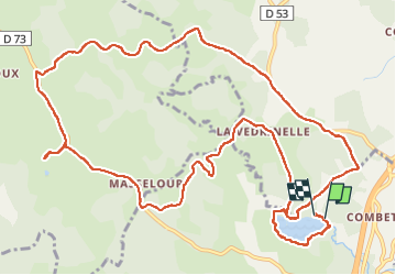

Length
16.9 km

Max alt
1165 m

Uphill gradient
323 m
Km-Effort
21 km

Min alt
1073 m

Downhill gradient
324 m
Boucle
Yes
Creation date :
2024-05-14 06:53:32.166
Updated on :
2024-05-14 11:26:01.931
3h39
Difficulty : Medium

FREE GPS app for hiking
 SityTrail
IGN / Geographical institutes
SityTrail Plus
The world is yours!
About
Trail Walking of 16.9 km to be discovered at Occitania, Lozère, Le Buisson. This trail is proposed by Alain28/01.
Description
Même sous la pluie,la région est magnifique.
Positioning
Country:
France
Region :
Occitania
Department/Province :
Lozère
Municipality :
Le Buisson
Location:
Unknown
Start:(Dec)
Start:(UTM)
518758 ; 4943375 (31T) N.
Comments